By Theta Pavis
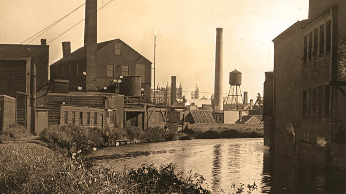
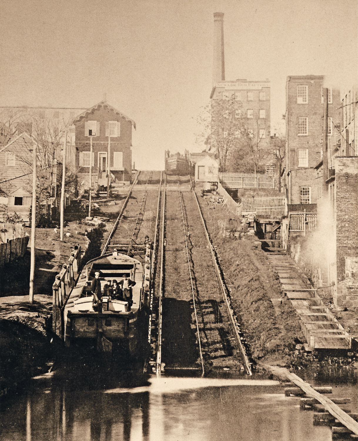
In the 19th century, the Morris Canal helped to catalyze industrialization in Newark. But the canal, which was completed in 1832, is long gone. A small team of NJIT professors and students have created a new map that focuses on the portion of the canal that ran near NJIT. Their work teaches us about the history right under our feet and reveals just how industrialized the area once was.
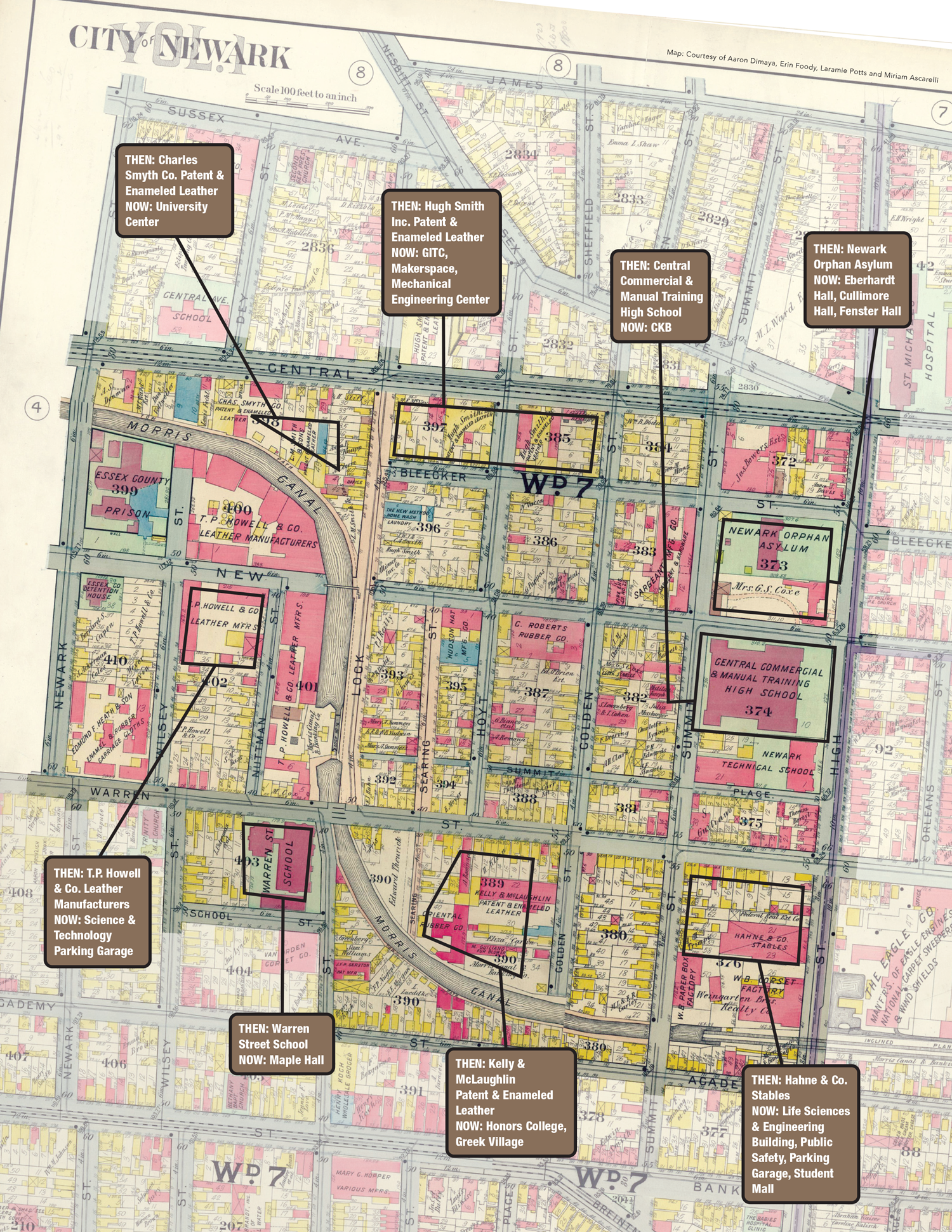
“This project makes it easier to see how prior to the creation of today’s campus, heavy industry, such as rubber and leather manufacturing, was concentrated in the area. Manufacturers wanted to be close to the canal so they could both transport their products and dump their waste,” said Miriam Ascarelli, a senior lecturer in the Department of Humanities and Social Sciences, who worked on the project with Laramie Potts, associate professor in the School of Applied Engineering and Technology (SAET).
The Morris Canal brought many goods, especially coal from eastern Pennsylvania to Newark and Jersey City, and ultimately to New York Harbor. Ascarelli said the canal helped bring what historians call “a market revolution’’ to New Jersey that transformed the economy.
The canal was closed in 1924 and was later transformed during the 1930s into the Newark Subway System — now the Newark Light Rail. Raymond Boulevard and Lock Street sit on the old canal pathway.
The map is part of a larger project that uses Geographic Information Systems (GIS) software to digitally layer and align historical maps of Newark on top of one another. This makes it easier to visualize changes that took place over time. The process is known as georeferencing.
Aaron Dimaya, a senior in the Surveying Engineering Technology program, was instrumental in georeferencing the maps. Erin Foody, a 2022 Civil Engineering graduate and a senior in the SET program (pursuing her second bachelor’s degree), also worked on the project. Both are part of the Albert Dorman Honors College. The research was funded by a faculty seed grant award to Ascarelli and Potts. Foody graduated in 2022 with a degree in civil engineering, then re-enrolled in NJIT to get a second bachelor’s degree in surveying in the SET program. She works at an engineering firm.
As a first step, the team decided to look at the past industrial footprint of today’s campus. The new map was created by layering the present-day campus over a map of the neighborhood as it existed in 1911, at the height of Newark’s industrial heyday. Eventually they want to use it to document the trajectories of other neighborhoods in the city.
“We envision incorporating demographic data into the maps in order to further flesh out how Newark evolved,” Ascarelli said. They plan on uploading images and other historical information so that viewers could click on specific locations and learn more. The current map shows where factories were located in and around what is now the NJIT campus.
A Trailblazing Collaboration
late 1880s on what is present day
Raymond Blvd., below NJIT.
Laramie Potts, the associate professor at SAET who worked with Ascarelli and the students, said, “This is a rich field of interdisciplinary research with Humanities leading the way in telling stories. It’s proving to be a rich collaboration in brainstorming what should be told, why and how. We’re looking at engineering and architecture and design, and what impact it had and how the future can be improved.”
Potts said the project has inspired Foody to do her senior project on flooding in Newark, where aging infrastructure and increased rainfall from climate change is having an impact. He hopes that the project can be made into a 4D version and that underground utilities can be mapped, helping engineers envision solutions for Newark. Ultimately, the framework they are building would allow anyone to put in their data. Eventually, he said, they hope to create an immersive experience with extended reality and virtual reality and to collaborate with other departments at NJIT, including the XR Lab.
Fast Facts
- To create their digital-mapping project, the NJIT team used maps from 1666, 1806, 1836, 1873, 1911 and 1961.
- The Morris Canal operated for almost 100 years and extended 102 miles from the Highlands of New Jersey (Phillipsburg on the Delaware River) then down through Newark and into Jersey City.
- Mule-drawn canal boats took five days to cross the state.
- The canal was New Jersey’s first industrial transportation system. It was considered an extraordinary technological achievement in its day, given that the canal had to traverse a mountainous landscape that involved an ascent of 760 feet from its starting point in Phillipsburg, to its high point near Lake Hopatcong. It then descended 914 feet to New York Harbor at Jersey City.
This was overcome through the construction of a series of inclined planes and locks. - After the canal closed, the city of Newark purchased the portion that ran through the city; the subway (now the light rail) was built on the canal bed.
Reading the Built Environment
Using computational tools, NJIT’s Digital Spatial History Lab (DSHL) is dedicated to temporospatial analysis of historical and contemporary environments. Current projects focus on the Mediterranean capitals of Rome and Istanbul from the 13th through the 21st century, using 3D simulation, virtual reality, ontological modeling, mapping and agent-based modeling. The lab examines the street shrines of Rome as an expression of vernacular devotion, revealing hidden communities while exploring forces that shape individual devotion from politics, to urban infrastructure and tourism. The Istanbul project focuses on the history of Ottoman/Turkish psychiatry by analyzing and mapping medical spaces, and by reconstructing the daily life and medical routines within mental hospitals. DSHL uses digital historical methods to pose larger questions about society, religion, culture or medicine by reading the built environment. During the 2024 Dana Knox Student Research Showcase, DSHL demonstrated how a video gaming platform was used to create virtual reality “exhibits” of these sites. DSHL is jointly run by Louis Hamilton, dean of the Albert Dorman Honors College, and Burcak Ozludil, associate dean.
To learn more: dh.njit.edu/labs/dshl
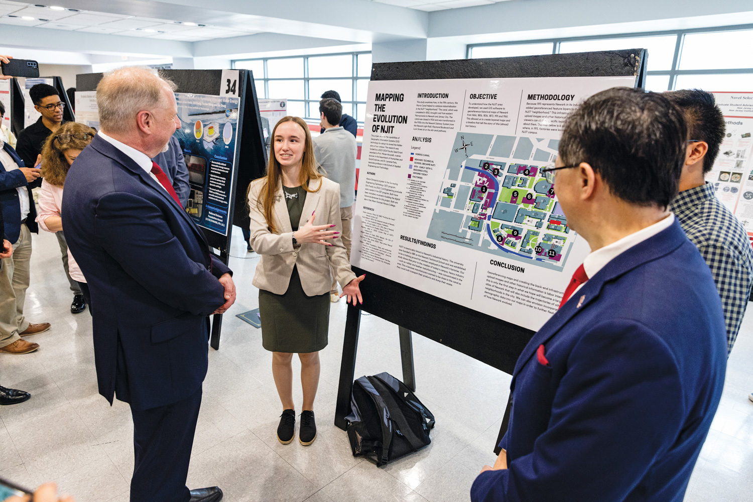
Undergraduates Erin Foody and Aaron Dimaya (not pictured) share their project “Mapping the Evolution of NJIT” with President Lim and Provost Pelesko during the Dana Knox Student Research Showcase.
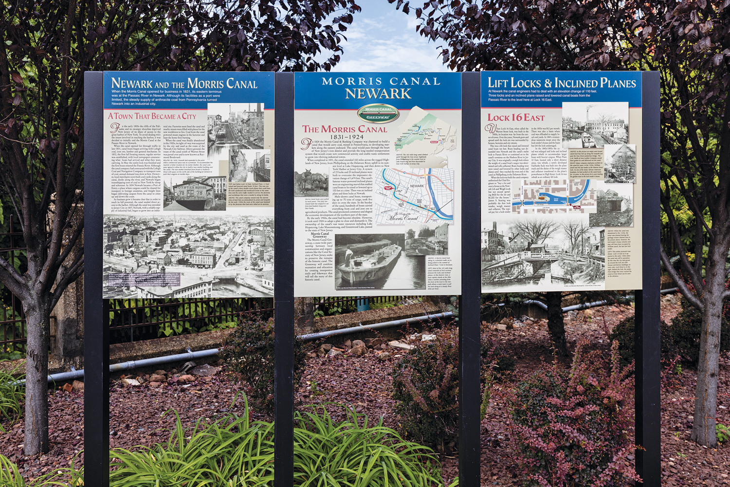
To see detailed signage installed by the Canal Society of New Jersey about the Morris Canal and Newark, visit the corner of Lock and New streets near campus.